April 27, 2026
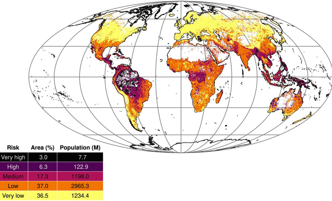
A groundbreaking global “disease risk map” has identified that approximately 9.3% of the world’s land area is highly vulnerable to the emergence of dangerous epidemics and pandemics. The study, led by veterinary epidemiologist Angela Fanelli at the European Commission’s Joint Research Centre (JRC), reveals a precarious intersection where climate change, rapid deforestation, and fragile healthcare systems create the perfect conditions for “spillover” events—when pathogens jump from animals to humans.
The research, published in Science Advances, provides a sophisticated blueprint for global preparedness, highlighting regions in Latin America, Asia, and Africa as high-priority zones. As three-quarters of emerging infectious diseases in humans are zoonotic in origin, this map serves as a critical early-warning system for a world still navigating the long-tail effects of previous global health crises.
Identifying the Red Zones: Key Findings
Using advanced machine-learning models, satellite imagery, and decades of climate data, the research team analyzed the habitat and transmission patterns of “WHO priority diseases.” These include high-consequence pathogens such as Ebola, Zika, and Crimean-Congo haemorrhagic fever.
The study categorized the Earth’s land into four distinct tiers of risk:
-
High-Risk: 6.3% of global land.
-
Very High-Risk: 3.0% of global land.
-
Moderate and Low Risk: The remaining land surface.
The geographical distribution of this risk is starkly uneven. Latin America faces the most significant pressure, with roughly 27% of its land classified as high or very high risk. It is followed by Oceania (18.6%), Asia (6.9%), and Africa (5.2%). By comparison, North America and Europe show less than 0.5% of their land in these elevated categories, though experts warn that in a globalized economy, “geographic risk” does not mean “geographic isolation.”
At the human level, the numbers are equally sobering. While only 3% of the global population resides in the highest-risk zones, nearly one-fifth of humanity lives in medium-risk areas. In these regions, a single localized outbreak could rapidly escalate, potentially overwhelming local clinical services before international aid can arrive.
The Drivers: Why Risk is Rising
The researchers identified nine primary drivers behind these rising threats. While environmental factors like rising temperatures and heavy rainfall play a role in expanding the range of mosquitoes and ticks, the study found that human activity remains the dominant catalyst.
-
Population Density: Emerged as the single strongest predictor of outbreak likelihood. High concentrations of people living in close proximity to disturbed ecosystems create more opportunities for transmission.
-
Land-Use Change: Deforestation for agriculture, mining, and road construction pushes humans deeper into previously untouched wildlife habitats.
-
Climate Instability: Higher temperatures and erratic rainfall patterns allow pathogens like dengue and chikungunya to survive in areas that were once too cool or dry.
-
Biodiversity Loss: When ecosystems lose species diversity, the remaining animals are often those that are “resilient” carriers of disease, such as certain rodents or bats, effectively concentrating the viral load in a specific area.
Beyond the Map: The Epidemic Risk Index
One of the study’s most significant contributions is the Epidemic Risk Index. This tool does not just look at where a virus might emerge (the hazard), but also at how well a country can handle it (the capacity).
By incorporating data from the International Health Regulations (IHR) on laboratory capacity and surveillance, the index identifies countries like Papua New Guinea and the Republic of Congo as being in a state of double jeopardy: they face high biological risk but possess limited resources to detect and contain an initial case.
“This index does not assign blame,” the JRC team noted in their summary. “Instead, it highlights where clinics, laboratories, and trained staff may be overwhelmed by a rapidly spreading pathogen.”
Expert Insights: Not a “Crystal Ball,” but a Shield
Global health experts emphasize that this data should be viewed as a proactive tool rather than a final destiny.
Dr. Jennifer Gardy, an infectious-disease epidemiologist at the University of British Columbia, noted that “these models are not crystal balls, but they are powerful tools for prioritizing surveillance and building resilient health systems before people actually start getting sick.”
Similarly, Dr. Salim Abdool Karim, a renowned global health epidemiologist in South Africa, remarked that the “convergence of climate change, land-use change, and urbanization is creating new frontiers of disease emergence.” He suggests the map is vital for tracking “Disease X”—the placeholder name for a currently unknown pathogen that could trigger the next global pandemic.
Moving Toward Preparedness: What Happens Next?
The practical implications for public health policy are clear. To prevent the next spillover from becoming a pandemic, international investment must be funneled into:
-
Early-Warning Surveillance: Monitoring animal health at the “human-animal interface,” such as wet markets and forest edges.
-
Laboratory Strengthening: Building diagnostic capacity in high-risk regions so that a “strange fever” is identified in days rather than months.
-
Platform Technologies: Developing vaccine frameworks that can be quickly adapted to new viruses as they emerge.
What This Means for You
For the general public, particularly those living in or traveling to high-risk regions, the study suggests several protective measures:
-
Vector Protection: Strict adherence to mosquito and tick bite prevention (insect repellent, nets).
-
Animal Safety: Avoiding contact with wild or sick animals and following food-safety protocols (e.g., avoiding raw “bushmeat”).
-
Proactive Care: Seeking immediate medical attention for unexplained fevers or neurological symptoms, especially if they follow travel to remote or high-risk zones.
Limitations of the Study
While comprehensive, the map is not exhaustive. It specifically focuses on zoonotic diseases currently listed as WHO priorities. It does not account for SARS-CoV-2-related variants or healthcare-associated infections (like “superbugs”). Furthermore, the model relies on historical data; regions with historically weak surveillance may be “under-mapped,” appearing safer than they truly are simply because past outbreaks went unreported.
References
Medical Disclaimer: This article is for informational purposes only and should not be considered medical advice. Always consult with qualified healthcare professionals before making any health-related decisions or changes to your treatment plan. The information presented here is based on current research and expert opinions, which may evolve as new evidence emerges.


