
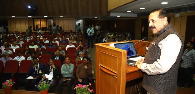
NEW DELHI — In an era where “location services” are the invisible heartbeat of modern life, India is fundamentally rewriting the mathematical script that defines where we stand. At the inaugural National Conference on Geodesy (GeodCon-26) held yesterday at the Indian National Science Academy (INSA), Union Minister Dr. Jitendra Singh declared that India’s mastery of geodesy—the science of measuring Earth’s geometric shape, orientation in space, and gravity field—has moved from a niche academic pursuit to a “strategic national strength.”
While terms like “geodetic reference frames” may sound removed from daily life, experts at the conference emphasized that this scientific leap is the hidden engine behind the next generation of public health interventions, precision emergency medicine, and climate-related disease tracking.
The “Invisible Foundation” of Modern Safety
Addressing a diverse audience of scientists, policymakers, and industry leaders, Dr. Singh highlighted the National Geospatial Policy 2022 as the turning point that democratized data access.
“Mapping represents the visible layer of development,” Dr. Singh noted, “but geodesy remains the invisible but essential scientific foundation that makes it possible.”
For the average citizen, this “invisible foundation” translates to the accuracy of the NavIC (Navigation with Indian Constellation) system. In medical terms, high-precision positioning is no longer just about finding the nearest hospital; it is about the “Golden Hour” of emergency response. When geodetic infrastructure is refined, GPS and NavIC accuracy moves from a margin of meters to centimeters.
Why Geodesy Matters for Health and Safety:
-
Precision Ambulances: Reducing navigation errors allows emergency services to bypass traffic and locate patients in high-density urban “canyons” where signals often bounce.
-
Disaster Resilience: Accurate gravity models allow for better prediction of floods and tectonic shifts, providing early warnings for communities at risk of waterborne disease outbreaks following natural disasters.
-
Environmental Health: Geodesy enables the precise monitoring of sea-level rise and groundwater depletion, two critical factors influencing long-term nutritional security and sanitation.
Expert Perspectives: From Math to Medicine
The conference highlighted the establishment of the National Centre for Geodesy (NCG) at IIT Kanpur, supported by six regional centers. Dr. M. Mohanty, Head of the NGP Division at the Department of Science and Technology, explained that these centers are now using GeoAI (Geospatial Artificial Intelligence) to monitor crustal deformations.
While the primary focus is structural, the health implications are profound. “A technologically advanced nation must maintain sovereign capability over its positioning systems,” Dr. Singh asserted.
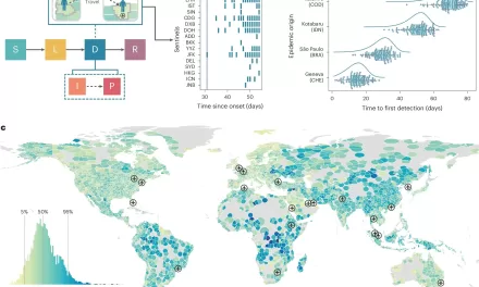
Independent public health experts suggest that this sovereignty allows for “Hyper-Local Epidemiology.” By layering high-precision geodetic data with health records, officials can identify disease clusters—such as dengue or respiratory illnesses—down to a specific block or apartment complex with unprecedented accuracy.
“When we talk about ‘Smart Cities’ and ‘Digital Health,’ we are really talking about precision,” says Dr. Aristha Sen, a geospatial health analyst not involved in the GeodCon proceedings. “If your geodetic frame is off, your data layering is off. You might think a malaria outbreak is centered in a park when it’s actually centered in a specific drainage canal 50 meters away. GeodCon-26 represents the tightening of that digital screw.”
Bridging the Gap: The Role of NavIC
A significant portion of the summit focused on NavIC. Unlike global systems maintained by other nations, NavIC is tailored to the Indian landmass. Dr. Singh noted that the success of Earth observation programs is tethered to this geodetic framework.
In practical terms, this supports the “One Health” approach—monitoring the intersections of human, animal, and environmental health. For example, tracking the migration patterns of zoonotic disease carriers (like birds or bats) requires the high-fidelity spatial data that only a robust national geodetic network can provide.
Challenges and Considerations
Despite the optimism, some experts at the conference urged caution regarding the “Digital Divide.” While the data is being liberalized, the capacity to use it effectively remains concentrated in urban centers.
Potential Limitations Include:
-
Hardware Integration: Older smartphones and medical devices may not yet be equipped to utilize the full precision of NavIC’s L5 and S-band signals.
-
Data Privacy: As geospatial data becomes precise enough to identify individual households, robust frameworks are needed to protect patient confidentiality.
-
Manpower Shortage: Dr. Singh acknowledged that “capacity building and development of skilled manpower” are essential. Without enough trained geodesists, the raw data cannot be translated into actionable health policy.
What This Means for You
For the health-conscious consumer, the takeaway from GeodCon-26 is that your “spatial environment” is about to become much clearer. In the coming years, you can expect:
-
Wearable Accuracy: More reliable altitude and location data on fitness trackers for outdoor enthusiasts.
-
Improved Telemedicine: Doctors will be able to verify environmental triggers (like local air quality or pollen counts) based on your precise location.
-
Faster Disaster Response: Local governments will have better “vulnerability maps” to prioritize elderly or disabled citizens during heatwaves or floods.
As India continues its march toward Aatmanirbhar Bharat (Self-Reliant India), the silent science of geodesy ensures that the nation isn’t just moving forward, but moving with pinpoint accuracy.
Statistical Context: The Growth of Geospatial India
| Metric | Status/Goal |
| Policy Foundation | National Geospatial Policy (2022) |
| National Centers | 1 Central (IIT Kanpur), 6 Regional |
| Target Accuracy | Centimeter-level positioning for strategic sectors |
| Economic Impact | Expected to contribute significantly to the $5 trillion economy goal via infrastructure efficiency |
Reference Section
Primary Sources:
-
Press Information Bureau (PIB): “National Geospatial Policy 2022 marked a landmark reform…” Posted 12 March 2026.
Medical Disclaimer: This article is for informational purposes only and should not be considered medical advice. Always consult with qualified healthcare professionals before making any health-related decisions or changes to your treatment plan. The information presented here is based on current research and expert opinions, which may evolve as new evidence emerges.


